


Cartography
Go back


 1561. MNM PM-2")


The cartographic collection on display at the Naval Museum is a large collection that includes 16th-century portulan charts and universal charts and pieces from some hydrographic commissions undertaken during the 18th and 19th centuries, as well as a collection of 10 globes, including celestial and terrestrial globes, and a valuable collection of facsimile maps and atlases.
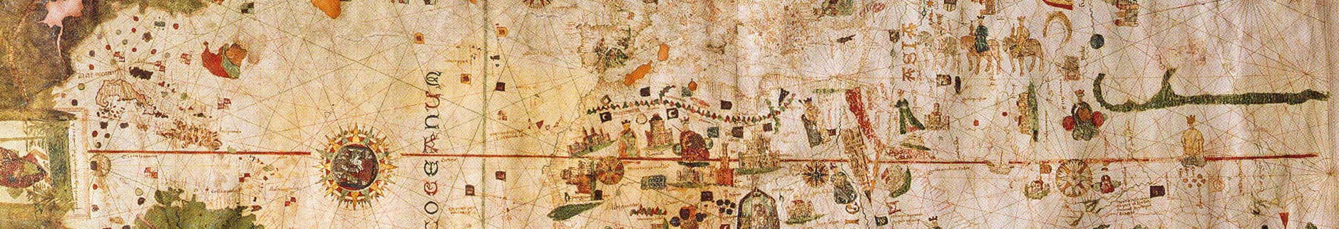
Portulan chartsThe Naval Museum's historical cartography collection includes the famous universal chart by Juan de la Cosa, produced in 1500, whose importance lies in the fact that it is the first cartographic representation of America. Other outstanding pieces in the collection are the portulan chart of the Mediterranean by Mateo Prunes from 1563, the portulan chart by Joan Martines from 1565, as well as the atlas by Diego Homen, ca. 1559.
18th- and 19th-century nautical chartsOn display are some 50 original charts belonging to scientific commissions carried out by the Spanish Navy to its former possessions in America, Africa and the Philippines during the 18th and 19th centuries. The collection is completed with some 240 facsimile charts and maps of extraordinary quality.
Earth globesThe cartographic collection includes ten globes and three armillary spheres. Outstanding mong them are the pair of globes by Coronelli, one terrestrial and the other celestial, from 1688 and 1693 respectively, as well as those by Seutter, Fremin and Delamarche –famous globe builders of the 18th and 19th centuries. Also noteworthy is a curious globe with a skirt case, the work of J. W. Cary, a member of the prestigious Cary dynasty, known for the production of maps and nautical instruments throughout the 18th and 19th centuries. The armillary spheres date from the 17th and 19th centuries and represent the geocentric and heliocentric systems.
AtlasesThe atlas collection was one of the first to be created, with the copies sent to Spain between 1789 and 1792 from England, France and Holland by the commander José Mendoza y Ríos on the order of the Minister of the Navy Antonio Valdés, to create a scientific library of the Navy in Cádiz. The collection was gradually increased with new atlases from donations and occasional acquisitions. Outstanding are the late 16th century editions of the Theatrum Orbis Terrarum by Ortelius, the Civitates Orbis Terrarum by Braun and the Thresoor der Zeevaert by Waghenaer. These atlases contain a large part of the charts from the period from 1780 to the end of the 19th century. Inside are charts from late 18th-century scientific expeditions and 19th-century hydrographic commissions.